Current Excavations
Season 4: Fall 2022
Introduction

The fourth season of excavations at the site of Tell al Hiba, ancient Lagash took place from the second half of October until the end of November (October 22-November 27, 2022). The joint project was led by Holly Pittman of the Penn Museum, University of Pennsylvania, supported by Sara Pizzimenti of the University of Pisa as field director.
Our work continues to investigate the urban social fabric of Lagash during the Early Dynastic period, using the methods of excavation, surface survey, UAV (drone) photography, mapping, and coring for geological and cultural samples. This season we added the use of magnetometry with the acquisition of a SenSys MXPDA Magneto 5 channel magnetometer.
Find out more about magnetometry this season on the Magnetometry on the Lagash Archaeological Project page.
Excavation
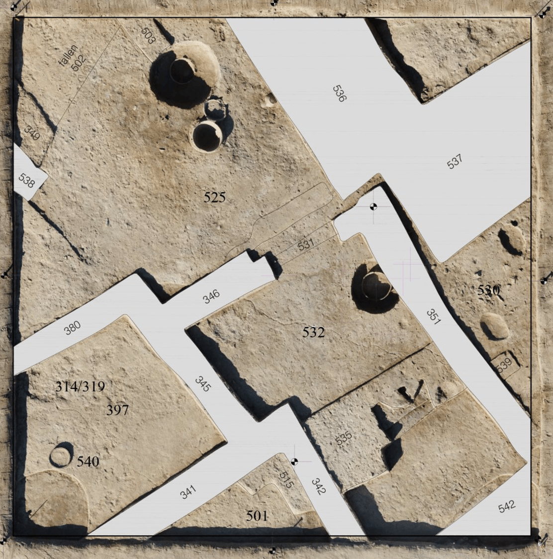
Excavation during this season was concentrated in Area H, where we opened four new operations. These are listed in order from SE to NW, as shown on the map at left.
Trench 3 Extension – A 10×10 meter eastern extension of Trench 3, which was opened in spring 2022
Trench 2 Extension – A 5×5 meter extension of Trench 2
Trenches 4+6 – A 10×10 eastern extension of Trench 4, opened spring 2022
Trench 5 – A new 10×10 meter trench opened to the west of Trench 6

Trench 3
A 10×10 meter extension of the spring season’s Trench 3 was opened in order to make clearer its stratigraphic connection with nearby Trench 2 and to gain a better understanding of the architecture and function of the building partially exposed during the previous season. The excavation revealed a continuous multi-phase sequence dating back from the Early Dynastic IIIB to the late Early Dynastic I.
The earliest phase so far uncovered, dating to the late ED I, comprises part of the same building excavated during the spring season immediately to the west. Seven rooms have been identified in the extension, including an open cooking space adjacent to a massive mud brick oven.
A smaller rectangular room on the western side, opening directly onto a courtyard that was excavated in the spring, yielded some of the most exciting finds from Trench 3 this season. On the plaster floor of this room were hundreds of ceramic bowls and beakers that seem to have fallen from shelves and benches along the eastern wall, many with their original content (food and drink, with plentiful animal bones and organic residue) still in situ.

Taken together, the massive oven, ancient refrigeration system, courtyard with benches, and large quantity of ready-to-eat food in conical beakers and bowls suggest that the building in Trench 3 was a public eatery serving the local neighborhood in the late ED I period.
Like Trenches 2 and 6, Trench 3 appears to have become a site for pottery production during the Early Dynastic IIIA, as indicated by the lower portions of two kilns located at the highest elevations within the trench.

In the southeastern corner of the same room was a large circular installation, which upon inspection proved to consist of the reused bottoms of two large jars, carefully cut and placed on inside the other, with the space between them packed with pottery sherds. This double ceramic feature appears to have been a cooling device for the storage of beverages.


The wall was found in the north-western corner of the trench. This structure was contemporaneous with the kilns as the working surfaces connected up to the wall. The southern kiln was bisected and the interior deposit layers were sampled.
The findings from this trench show that pottery production was a highly organized industry in the ED IIIA period, and that the crafts-people of Lagash utilized methods such as a closed kiln discharge pit to keep messy industrial work more clean, supported not only by the discharge pit itself but by the lack of ash and waste on the working surface in the west of the trench. It also shows that pottery production was quite high at Area H in the ED IIIA and that production demand required the need for multiple kilns to be used simultaneously. It also shows that kilns were used for multiple production cycles with rounds of waste deposits, breaking down of the kiln roof and rebuilding (as indicated by layers of kiln wall chunks found in the east), and new working surfaces added with new production cycles.
Trench 2
This season an extension to trench 2 was opened after magnetometry indicated that two additional kilns and a wall structure were present. Through the excavation, multiple phases of use of this pottery production area were understood. First, only the northern kiln was used, then an additional kiln was built directly to the south. The kilns were built with enclosed discharge pits attached to their eastern sides, with a fire hole leading out from the kiln into the discharge pits. To the west of the kilns were clean working surfaces with beaten earth floors. Multiple surfaces and corresponding waste deposit layers were found, indicating multiple cycles of use. Multiple surfaces also connected to both the northern and southern kilns, showing both were used contemporaneously for more than one cycle. The uppermost working surface was found only connecting to the southern kiln, indicating that after a few cycles they decommissioned the northern kiln and had a phase only using the southern kiln.


Trench 6
Area H Trench 6 expanded and helped to clarify our understanding of Trench 4 (opened in spring 2022) in relation to the pottery production contexts of Trench 2. A sequence of four phases was identified, dating from the end of ED I to the ED IIIB.
The latest phase was represented by a series of pits and by three walls defining a central space. Below this was a phase of construction dated to the ED IIIA, in which a street was identified running horizontally across the north of the trench. In addition, two floors were defined between a series of walls that defined an interior courtyard space.
The street continued along the same axis in the third phase, here with a door providing access to a narrow alley. Four rooms were defined in this phase, including a courtyard with three benches. In another of these rooms was a unique deposit: a rectangular basin filled with pure red clay full of small freshwater mollusks. This type of clay was used especially for pottery, suggesting that this area accommodated seasonal work of soaking and refining clay in preparation for pottery manufacture.


The earliest phase defined during this season appears to date to a transitional period between the end of ED I and the beginning of ED IIIA. One deposit, enclosed by walls to the west of the alley, consisted of another type of pure clay. This clay was intermixed with yellowish, ultra-pure sand, which might have served as a tempering agent for pottery.

The latest phase preserved in the area was documented by several drains, pits, and one grave. Among the pits was one which yielded a large number of inverted conical bowls. Two large vats, packed with potsherds and concrete sediment, were also identified in this surface layer, were also found in this surface layer. These seem to be installations for keeping foodstuffs or commodities cool.
The ED IIIB was attested in multiple phases in Trench 5. Within the ED IIIB phase, an additional grave of a child was found. Remains in phase 3 included an imposing building (the North-Eastern Building) with walls of plano-convex mudbricks. An interior floor in this phase preserved traces of a mat laid over the remains of a fish, as well as jar stoppers, animal bones, and potsherds piled against one wall.
An earlier construction, designated the Main Building, was present in the late ED I to ED IIIA transitional phase. This structure likely fell into disrepair before the construction of the North-East Building, although the latter accommodated its plan to the ruins of the former. During the period of its use, the Main Building appears to have been residential, with plaster floors, a bench and platform, and objects including stone tools and vessels, flints, beads, clay jar stoppers, and tokens.
Trench 5
The location of Trench 5, to the west of Trenches 4 and 6, was chosen to ground-truth the results of gradient magnetometry survey carried out at the beginning of the campaign, which clearly indicated the presence of buildings and other structures. Excavation revealed a continuous multi-phase sequence dating between the ED I and the ED IIIB.
Test Pits
Four 2×3 meter test pits were placed across a fluvial feature visible on the surface of the site that suggested significant perennial flow, possibly a water channel. We wanted to characterize and date the channels, particularly to understand if they were contemporary with the Early Dynastic city.
Pisé and mudbrick architecture of the ED period was found within a depth of two meters in every one of the test pits, clearly indicating that the water channel postdated the area’s Early Dynastic occupation. An inscribed clay nail of Enanatum I was also found embedded in a mudbrick floor in Test Pit 2.


Test pit 3 with conical bowl on brick surface
Material Culture
 |
A dedicatory clay nail inscription found in Test Pit 2 in the northern part of the site names Enanatum I, ruler of Lagash, and Lummatur, his son. It commemorates the building of the Ibgal temple of Inana, which was excavated by the NYU/Metropolitan Museum team in Area A. |
Under the direction of Dr. Sara Pizzimenti, the team processed more than 36,965 pottery sherds during the fall 2022 season. Of these, 9,599 diagnostic sherds (rims, bases, and decorated body sherds) were photographed and analytically recorded in a database, and a selection of these were drawn.
 |
 |
| A large number of clay and bitumen sealings for containers and doors were excavated this season, of which five bore the impressions of cylinder seals. |  |
Surface Survey and Remote Sensing
Surface Survey
The systematic GPS and mobile GIS-enabled surface survey begun in the 2022 spring season was resumed and completed in the fall season. In all, 1,783 pre-plotted target locations on a 50-meter grid were sampled, and collections were made at each location that had surface artifacts. Processed artifacts were categorized by type, counted, and weighed, and the resulting densities will be plotted as heat maps in GIS as a guide to suggest the different activities (such as extensive pottery production) for which parts of the site were used.


Remote Sensing
UAV drone photography
The same DJI Phantom 4 RTK drone used in the 2021 (2LAP) and spring 2022 (3LAP) seasons was deployed again this season for site-level aerial photography. Flights in Area H after the recent rains, in particular, highlighted areas of differing soil color which give clues to the location of residential neighborhoods, ancient streets and walls, and possible courses of ancient waterways. Additionally, the drone was flown over the northern mound after a rainstorm. As in the south of the site, this area of over 130 hectares also revealed extensive networks of roads and structures.

Magnetometry
This season nearly 7 hectares were surveyed via magnetometry, revealing subsurface architecture in great detail. Most of the survey units were selected around Area H to guide our interpretation of the ancient city plan in that part of the site, but six units were selected north of the Sayyid’s Tomb to assist in our interpretation of the results from the soundings conducted there, and one unit was selected south of Area G to explore the architecture there, with a final unit selected to investigate a possible ancient cemetery. Where magnetometry units intersected our Area H trenches, we found a tight correlation between streets and walls in the magnetometry data and those revealed in excavation.
See more on the Magnetometry on the Lagash Archaeological Project page.


Above, left: UAV (drone) image of monumental square feature east of Area G
Above, right: Magnetogram of monumental square feature east of Area G
Geoarchaeology
This season we augered an additional water feature, which appears on the surface as a modern wadi, to the east of Area H, to determine its age, general character, and relation to architectural-like features detected by remote-sensing. Overall, we understand that this linear wadi feature is modern and unrelated to the archaeological strata at Lagash.
Training
During the Fall 2022 season, the LAP expanded its training offerings for Iraqi colleagues. In addition to training our workmen in skills of excavation, we provided a three day training session for three colleagues from SBAH in Baghdad. The training included an introduction to the site and to the goals of the project in the evening when they arrived. During the first day of training, they participated in the surface survey designed and directed by Dr.Paul Zimmerman. The survey is designed to be registered on a GPS ipad which has the recording form in both English and Arabic. During the second day of training, the SBAH trainees participated in the excavations in Area H, and were trained in the recording process as well as drone photography for photogrammetry. Locally, Dr. Paul Zimmerman trained Mohammad M’Tasher in the processing of survey finds. Furthermore, Mohammad was trained in the programming, setting up, and use of the Total Station.
The LAP project provided funds for the local primary school to improve its facilities. Thanks to these funds, the school’s courtyard was paved, a new pipe for running water was laid, and the bathrooms were given new roofs.


